Volcano & Management
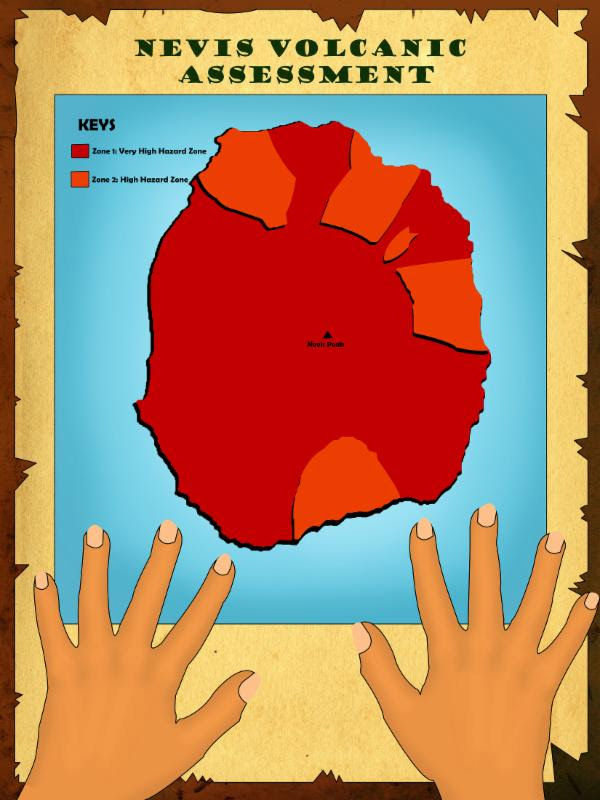
A mountain that opens downward to molten rock — and a defining feature of Nevis. Nevis Peak is a dormant stratovolcano; the danger area can extend 20 miles in all directions, sometimes 100 miles or more.
Volcano Awareness from Joycelyn Liburd Primary School
Awareness content produced by the Joycelyn Liburd Primary School (formerly Gingerland Primary School) — featuring the Head Teacher and the school community.
Head Teacher — Volcano Awareness
Volcano Awareness — JLPS Students
What is a Volcano?
A volcano is a mountain that opens downward to a pool of molten (melted) rock below the surface of the Earth. Unlike most mountains, which are pushed up from below, volcanoes are vents through which molten rock escapes to the Earth's surface. When pressure from gases within the molten rock becomes too great, an eruption occurs — eruptions can be quiet or explosive.
When an eruption occurs, there may be lava flows, flattened landscapes, poisonous gases, flying rocks, and ash that can sometimes travel hundreds of miles downwind.
Nevis is itself a volcanic island — Nevis Peak (985 m) is a dormant stratovolcano. It hasn't erupted in modern history but its geological profile is well-documented and monitored as part of the wider eastern Caribbean volcanic arc.
Where Is the Danger?
The danger area around a volcano covers approximately a 20-mile radius in all directions. However, some danger may exist 100 miles or more from the volcano — ash plumes carry far on the wind, mudflows follow river valleys, and pyroclastic flows can travel down slopes at terrifying speed.
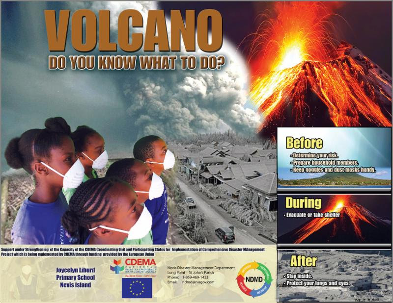
What to Do
Before
Prepare the kit and the family long before any unrest is reported.
- Build an emergency kit (water, dust masks, goggles, food, flashlight, battery radio)
- Make a family communication plan and identify your meet-up point
- Know the evacuation routes for your parish and your nearest designated shelter
- Keep face masks (N95) and protective eyewear ready for ash fall
During
Follow officials, watch for mudflows, protect your lungs and eyes.
- Follow evacuation orders from emergency officials immediately
- Look out for mudflows — a fluid or hardened stream of mud
- Look upstream before crossing a bridge — if a mudflow is coming, do NOT cross
- Stay indoors if not under evacuation order; close all windows, doors and dampers
- If outside, protect against ash with dust mask, goggles and long sleeves
- Avoid low-lying areas and river valleys downstream of the volcano
After
Ash hazards continue long after the eruption — pace yourself.
- Listen to safety officials before returning home
- Text, don't talk — voice calls block phone lines for emergency workers
- Wear a mask outdoors — falling ash damages lungs
- Sweep ash from roofs as soon as it's safe — accumulation can collapse buildings
- Don't drive in heavy ash fall (visibility hazard, clogs engines)
- Avoid contact with ash — wash skin and clothing as soon as possible
Volcano Alert Levels
The international USGS-aligned four-level alert system used by monitoring agencies — including the Montserrat Volcano Observatory just to our south.
Normal
Typical background activity. No eruption suggested.
→ Stay aware — sign up for alerts.
Advisory
Elevated unrest above background levels. Eruption uncertain.
→ Watch for updates; check evacuation routes.
Watch
Heightened unrest with increased potential for eruption — timeline uncertain.
→ Prepare to evacuate; pack go-bag.
Warning
Hazardous eruption imminent, underway or suspected.
→ Evacuate immediately if ordered.
Nevis Geological Profile
Official Nevis geological profile from NDMD — covers the island's volcanic origin, rock types, fault structure and known eruption history.
Words to Know
Travelling at 50–100 miles per hour and reaching temperatures over 1,000°C, pyroclastic flows are the volcanic phenomenon that has killed the most people through history. They follow valleys, can cross water, and outrun anything in their path. If you're under a Watch or Warning — evacuate immediately when told.
Sign Up for Volcano Alerts
NDMD coordinates with the wider eastern Caribbean volcanic monitoring network. Subscribe to receive any alert level change for Nevis Peak directly to your phone.