Tsunami & Coastal Inundation
A series of giant waves — up to 100 feet high, travelling 450 miles an hour in open sea — set off by earthquakes, volcanic eruptions, landslides or meteor impacts. The Caribbean has had them before, and the Lesser Antilles arc makes us vulnerable.
Tsunami Awareness from Elizabeth Pemberton Primary School
Tsunami awareness content from EPPS — the leading school in St. Kitts and Nevis tsunami education. Three short videos covering basics, preparedness tips, and natural warning signs.
Tsunami Awareness — EPPS as Leading School
Tips Before a Tsunami
Tsunami Warning Signs
What is a Tsunami?
A tsunami (pronounced soo-nah-me) is a series of giant waves that happen after earthquakes, volcanic eruptions, landslides or meteoric impacts (Earth being hit by a meteor). The waves travel in all directions from the area of disturbance, much like the ripples that happen after throwing a rock into a pond.
The waves may travel as fast as 450 miles an hour in the open sea. As big waves approach shallow waters along the coast they grow to a great height and smash into the shore. They can be as high as 100 feet and can cause a lot of damage along the shore.
Tsunamis arrive as a series of waves, not a single one. The first wave can be small — followed minutes or even hours later by waves several times larger. Stay on high ground until officials give the all-clear, no matter how calm the sea looks between waves.
Where Do Tsunamis Happen?
Tsunamis generally appear in the Pacific Ocean and coastal areas. But the Caribbean has had them before — the 1867 Virgin Islands tsunami struck St. Kitts and Nevis with multiple waves following a major earthquake — and the Lesser Antilles volcanic arc makes the eastern Caribbean coastline vulnerable.
Highest-risk zones in Nevis include:
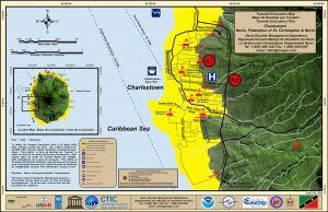
- Charlestown waterfront — low elevation, dense population (see evacuation map below)
- Pinney's Beach and the leeward tourism corridor
- Newcastle — including airport low-ground
- Any low-lying coastal road along the Round Road
Natural Warning Signs
A tsunami can arrive minutes after the triggering earthquake — faster than any official warning. Recognise the natural signs and act on them.
Strong Earthquake
If you feel a strong earthquake near the coast — long, slow shaking lasting 20+ seconds — assume a tsunami is coming. Don't wait for an official warning.
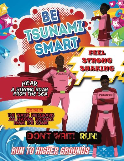
Water Receding
The ocean visibly draws back from the shore — exposing seafloor, fish and rocks normally underwater. This is the trough of the tsunami before the crest arrives. Move inland NOW.
Loud Roar
A sound like a freight train or jet engine coming from the ocean. The wave is close enough to hear — already too close to escape on foot.
If you see the ocean drop noticeably from the shoreline, exposing the seafloor — that is nature's warning that a tsunami is coming. The water is being pulled out to feed the wave. You may have only minutes. Get inland and to higher ground immediately. Do not stop to film or watch.
What to Do
Before
Know the route. Pack the kit. Learn the signs. There may be only minutes of warning.
- Build an emergency kit (water, food, flashlight, battery radio, first aid, important documents)
- Make a family communication plan and identify your inland meet-up point
- Know your nearest evacuation route to higher ground (see maps below)
- Know the natural warning signs — strong earthquake near the coast, water receding from shore, ocean roar like a freight train
- If the water recedes from the shoreline noticeably — get away from the area immediately. This is nature's warning that a tsunami is coming
- Sign up for tsunami alerts via the St. Kitts & Nevis Tsunami Protocol
During
Move inland and uphill. If you can see the wave, you are too close to escape it.
- Listen to evacuation orders and leave the area immediately
- Take any pets with you
- Move INLAND (away from the ocean) and toward higher ground — at least 100 ft above sea level if possible
- Stay away from the beach. Never go down to the water to watch a tsunami come in
- If you can see the wave — you are too close to escape it
- Do not wait for an official warning if you feel a strong earthquake near the coast — evacuate
- Climb up, not out — a 3-storey reinforced concrete building is safer than driving on jammed coastal roads
After
Wait for officials. Expect more waves. Stay off the coast.
- Don't return home unless officials tell you it is safe to do so
- Stay away from debris in the water — it could be dangerous
- Stay out of any building with water around it. Water can make floors crack or walls collapse
- Text, don't talk — voice calls block phone lines for emergency workers
- Expect multiple waves — the first wave is rarely the largest, and they can arrive hours apart
- Avoid contact with floodwater — it carries debris, raw sewage and electrical hazards
- Help neighbours and check on the elderly, young children and people with disabilities
Tsunami Alert Levels
The official four-level alert system used by the National Tsunami Warning Center and adopted under the St. Kitts & Nevis Tsunami Protocol.
Information Statement
An earthquake has occurred or a warning/watch/advisory has been issued for another section of ocean. No threat of a destructive basin-wide tsunami.
→ Stay aware.
Watch
Issued to alert officials and the public of an event that may later impact the area. May be upgraded to Advisory or Warning — or be cancelled.
→ Check in; be ready to act.
Advisory
A tsunami with the potential to generate strong currents or waves dangerous to those in or very near the water is imminent, expected or occurring.
→ Stay out of the water; off beaches.
Warning
A tsunami with potential to generate widespread inundation is imminent, expected or occurring. Dangerous coastal flooding and powerful currents possible.
→ Evacuate to higher ground NOW.
Tsunami Evacuation Maps
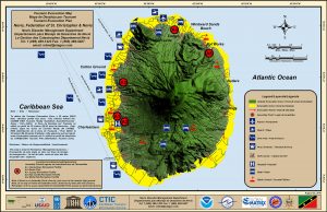
Official NDMD tsunami evacuation maps — for the Charlestown waterfront and the full island. Print one, post it at home and work, and walk your evacuation route at least once before you ever need it.
Charlestown Evacuation Map
Nevis Island-Wide Evacuation Map
Words to Know
Every year, St. Kitts and Nevis participates in CARIBE WAVE — the Caribbean-wide tsunami exercise coordinated through UNESCO. Watch for the announcement, practice the evacuation with your family, and treat it as the real thing. Drilling is the only way you'll act fast when it matters.
Sign Up for Tsunami Alerts
NDMD operates under the St. Kitts & Nevis Tsunami Protocol — coordinated with the National Tsunami Warning Center and regional partners. Subscribe to receive any tsunami advisory or warning for the Federation directly to your phone.