Hurricane & Management
Severe tropical storms with winds of at least 74 mph — the defining hazard of the Caribbean's June-to-November season.
What is a Hurricane?
Hurricanes are severe tropical storms that form in the southern Atlantic Ocean, the Caribbean Sea, the Gulf of Mexico and the eastern Pacific Ocean. They gather heat and energy through contact with warm ocean waters — evaporation from the seawater increases their power.
Hurricanes rotate counter-clockwise around the centre of the storm — the eye. They have winds of at least 74 miles per hour and bring heavy rain, strong winds and large waves that can damage buildings, trees and vehicles.
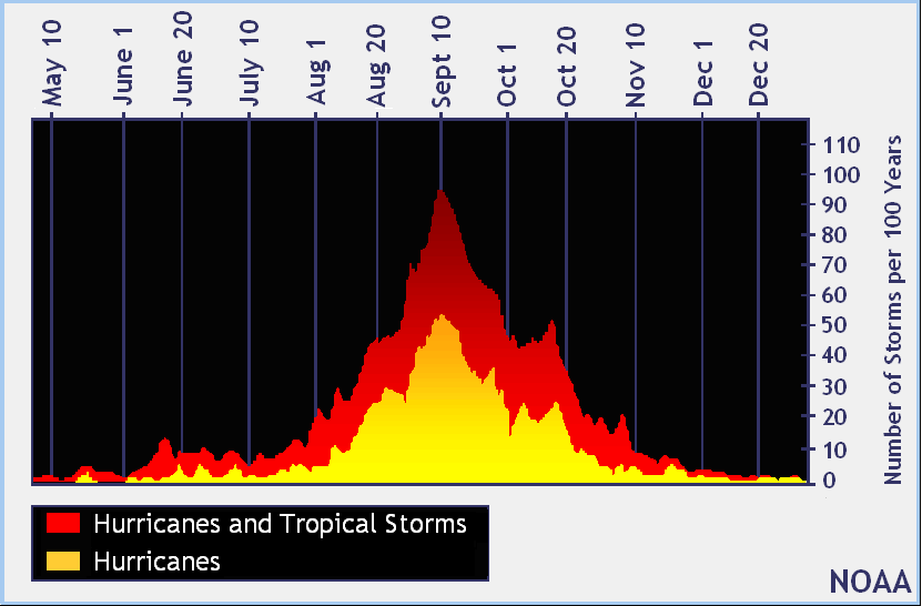
Hurricanes are most common between June and November — Atlantic hurricane season — and are known to affect Caribbean islands. The peak months are August and September.
What to Do
Before
Prepare the house, the family and the kit before the season starts.
- Build an emergency kit (water, non-perishable food, flashlight, first-aid, battery radio, cash)
- Make a family communications plan and identify your meet-up point
- Bring indoor: potted plants, patio furniture, decorations, garbage cans — anything that can fly in strong winds
- Trim trees and remove dead branches near the house
- Know your nearest designated shelter and your evacuation route
- Fill vehicles with fuel and charge phones, laptops and battery banks
During
Shelter in place — and don't be fooled by the eye.
- Don't open the refrigerator or freezer — if you lose power, keep the cold air inside
- Stay away from windows and glass doors — they could break and hurt you
- Don't go outside when the rain or winds stop — this is the eye of the storm, and the rain and winds will start again
- Listen to safety officials on radio for important instructions
- Stay in an interior room on the lowest floor if possible
- If flooding rises — move to higher ground inside the building
After
The danger isn't over when the wind stops.
- If you are a child, do not go outside without an adult
- Don't go near any wires that are loose or dangling — they could electrocute you
- Be alert for the smell of gas
- Don't drink water from the faucet unless safety officials say so
- Text, don't talk — voice calls block phone lines for emergency workers
- Take photos of damage for insurance before clearing up
- Check on elderly neighbours and people who live alone
Hurricane Categories
The Saffir-Simpson scale ranks hurricanes 1 to 5 by sustained wind speed — and tells you what to expect from each.
Minimal damage — unanchored mobile homes, vegetation and signs
Moderate damage — all mobile homes, roofs, small craft, flooding
Extensive damage — small buildings, low-lying roads cut off
Extreme damage — roofs destroyed, trees down, beach homes flooded
Catastrophic — most buildings destroyed, vegetation gone, major roads cut off
Hurricane Tracking Chart
Print the NOAA Atlantic tracking chart and plot every storm as advisories come in.
NOAA Hurricanes & Tropical Storms
Reference chart from the National Oceanic and Atmospheric Administration.
Beaufort Wind Chart
How to Prepare for a Hurricane
Full preparedness guide — read the embedded version below, or download to keep offline.
NEVLEC's Hurricane Preparedness Plan
How Nevis's electricity utility prepares the grid for a storm.
Words to Know
The eye is a deceptively calm gap in the centre of the storm — clear skies, light wind, no rain. It can last from a few minutes to over an hour. The instant it passes, hurricane-force winds return from the opposite direction, often more violently. Stay sheltered until safety officials give the all-clear.
Hurricane Relief Application
If you've been affected by a hurricane, NDMD coordinates the relief application process. Apply online or pick up the form from the office.