Robert L. Bradshaw International Airport
St. Kitts Meteorological Services
St. Christopher Air & Sea Port Authority
P.O. Box 963
Basseterre
St. Kitts
Tel: 869 465 2749 Tele- fax: 869 465 9122
Weather Bulletin
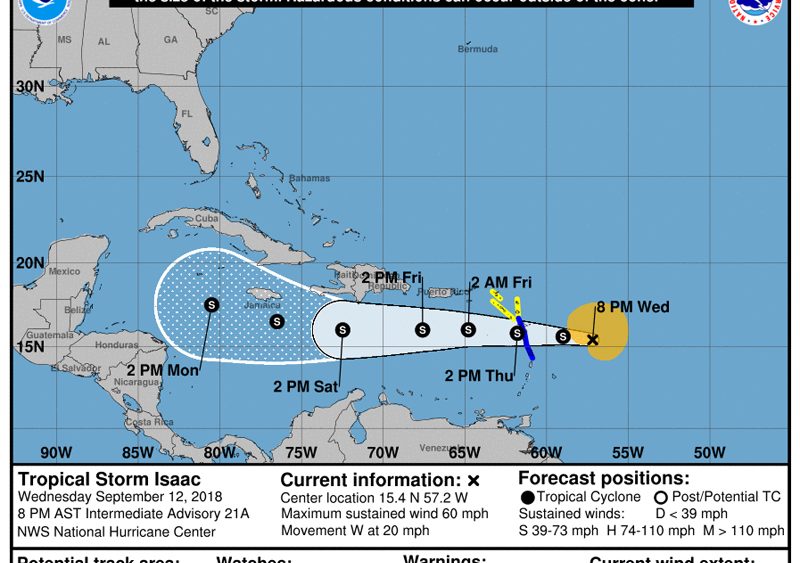
A TROPICAL STORM WATCH REMAINS IN EFFECT FOR ST. KITTS AND NEVIS. A tropical storm watch means that tropical storm conditions are possible in the specified area within 48 hours.
At 500 pm AST (2100 UTC), the center of tropical storm Isaac was located near Latitude 15.4 North, Longitude 56.6 West or about 374 miles east southeast of St. Kitts and Nevis. Isaac is moving toward the west near 20 mph (31 km/h), and this general motion with a decrease in forward speed is expected to continue through the weekend. On the forecast track, Isaac is forecast to move across the Central Lesser Antilles and into the Eastern Caribbean Sea on Thursday, and then move across the eastern and central Caribbean Sea through Saturday.
Maximum sustained winds remain near 60 mph (95 km/h) with higher gusts. Some weakening is forecast during the next 48 hours.
Tropical-storm-force winds extend outward up to 175 miles (280 km) from the center.
The estimated minimum central pressure is 1003 mb (29.62 inches).
Based upon the latest position and analyses, tropical storm Isaac is expected affect St. Kitts and Nevis early Thursday and the Tropical Storm watch remains in effect for St. Kitts and Nevis.
Wind gusts in excess of 40 miles per hour are possible with the passage of Isaac. This means that small and loose objects must be secured.
Rainfall total of up to an inch is possible and flood advisories may become necessary.
Seas will deteriorate with a combination of wind driven waves and swells peaking near 3.1 metres or 10 feet. Small craft operators should stay in port and sea bathers should avoid the beaches until Isaac exits the area.
Repeating the 5 pm position, Location 15.4N, 56.6W. Movement w at 20 miles per hour. Maximum sustained winds 60 mph. Minimum central pressure…1003 mb…29.62 inches
The next advisory will be 11 pm tonight.


