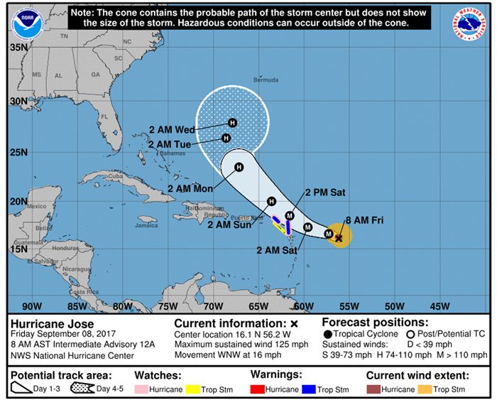
Hurricane Jose Intermediate Advisory Number 12A
NWS National Hurricane Center Miami FL AL122017
800 AM AST Fri Sep 08 2017
…JOSE MAINTAINING STRENGTH OVER THE CENTRAL ATLANTIC…
SUMMARY OF 800 AM AST…1200 UTC…INFORMATION
———————————————-
LOCATION…16.1N 56.2W
ABOUT 480 MI…775 KM ESE OF THE NORTHERN LEEWARD ISLANDS
MAXIMUM SUSTAINED WINDS…125 MPH…200 KM/H
PRESENT MOVEMENT…WNW OR 285 DEGREES AT 16 MPH…26 KM/H
MINIMUM CENTRAL PRESSURE…957 MB…28.25 INCHES
WATCHES AND WARNINGS
——————–
CHANGES WITH THIS ADVISORY:
None.
SUMMARY OF WATCHES AND WARNINGS IN EFFECT:
A Hurricane Watch is in effect for…
* Antigua, Barbuda, and Anguilla
* Sint Maarten
* St. Martin
* St. Barthelemy
A Tropical Storm Warning is in effect for…
* Antigua, Barbuda, and Anguilla
A Tropical Storm Watch is in effect for…
* Montserrat, St Kitts, and Nevis
* Saba and St. Eustatius
A Hurricane Watch means that hurricane conditions are possible within the watch area. A watch is typically issued 48 hours before the anticipated first occurrence of tropical-storm-force winds, conditions that make outside preparations difficult or dangerous.
A Tropical Storm Warning means that tropical storm conditions are expected somewhere within the warning area within 36 hours.
A Tropical Storm Watch means that tropical storm conditions are possible within the watch area, generally within 48 hours.
For storm information specific to your area, please monitor products issued by your national meteorological service.
DISCUSSION AND 48-HOUR OUTLOOK
——————————
At 800 AM AST (1200 UTC), the eye of Hurricane Jose was located near latitude 16.1 North, longitude 56.2 West 435 miles East Southeast St. Kitts & Nevis. Jose is moving toward the west-northwest near 16 mph (26 km/h). A slower west-northwestward motion is expected during the next couple of days. On the forecast track, Jose is expected to be near the northern Leeward Islands on Saturday.
Maximum sustained winds are near 125 mph (200 km/h) with higher gusts. Jose is a category 3 hurricane on the Saffir-Simpson Hurricane Wind Scale. Some slight strengthening is possible later today or tonight.
Hurricane-force winds extend outward up to 35 miles (55 km) from the center and tropical-storm-force winds extend outward up to 115 miles (185 km).
The estimated minimum central pressure is 957 mb (28.25 inches).
HAZARDS AFFECTING LAND
———————-
WIND: Hurricane conditions are possible within the hurricane watch area on Saturday, and tropical storm conditions are expected within the tropical storm warning areas by Saturday morning. Tropical storm conditions are possible in the tropical storm watch areas by Saturday morning.
RAINFALL: Jose is expected to produce total rain accumulations of 2 to 6 inches in the Leeward Islands from Dominica to Anguilla. Isolated maximum amounts of 10 inches are possible in the northern Leeward Islands from Antigua and Barbuda to Anguilla. This rainfall will maintain any ongoing flooding and may cause additional life threatening flooding.
SURF: Swells generated by Jose are expected to affect portions of the Leeward Islands by later today. These swells are likely to cause life-threatening surf and rip current conditions. Please consult products from your local weather office.
NEXT ADVISORY
————-
Next complete advisory at 1100 AM AST.


